NewsTracker Answers for week of July 30, 2012

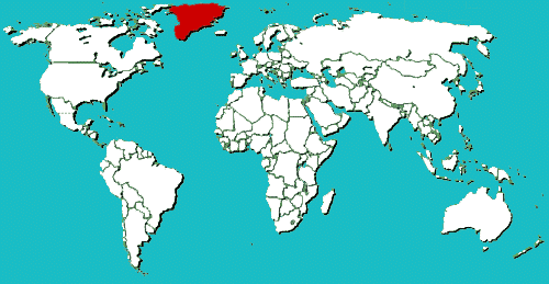
Q: Satellite images show that the surface of Greenland's massive ice sheet has melted this month over an unusually large area – jumping from 40 percent to 97 percent in just four days. Where is Greenland on this map?

Circle the area on this map


Q: It may be tempting to link the event to global warming, but scientists say such melts might occur about every 150 years and it could be the result of unusual weather. How much would sea levels rise if all of Greenland's ice were ever to melt?

A. 3 feet

B. 23 feet

C. 53 feet

D. 103 feet


B. Scientists estimate that if all of Greenland's ice sheet were to melt, the global sea level would rise by 23 feet (7 meters). "To be perfectly clear, that is not what we're seeing," said researcher Thomas Mote. "Greenland is losing mass, but it would take a very long time to lose all of that mass."


Q: With a total area of 836,330 square miles, Greenland is the third largest country in . . .

A. North America

B. Europe

C. Asia

D. The world


A. Greenland is considered part of the North American continent, and its closest neighbor is Canada -- North America's largest country. Greenland's 57,695 people have self-rule over most domestic affairs, but the country is part of the Kingdom of Denmark which oversees foreign policy, security and financial affairs.


Q: Greenland's ice sheet is 677,855 square miles and covers how much of the country?

A. 52 percent

B. 66 percent

C. 81 percent

D. 99 percent


C. The ice sheet covers 81 percent of the territory and is up to two miles thick in spots. All the towns and settlements are situated along the ice-free coast, with the population being concentrated along the west coast.


Q: If Greenland's ice sheet melted, what do scientists believe it would reveal?

A. An archipelago

B. A frozen forest

C. An ancient city

D. Nothing but rocks


A. Greenland is considered the world's largest island, but scientists believe the ice actually covers a cluster of smaller islands.